The Relationship Between Deforestation and Property Rights in Bolivia
This blog explores the relationship between property rights and deforestation in Bolivia by superimposing recent deforestation (2016-2021) on rural property rights data from 2016. It sounds like a very simple exercise, but, as we will show in this blog, property rights in Bolivia are quite complicated.
The INRA Law (Law No. 1715, passed in 1996) creates six different types of property rights. While some types of properties are highly protected by the law, others can be confiscated if not used productively:
- Solar Campesino: Subsistence farm (cannot be divided, nor confiscated)
- Pequeña Propiedad: Small, rural property using family labor and producing mainly for subsistence (cannot be divided, nor confiscated)
- Mediana propiedad: Medium-sized rural property using hired workers and selling products to the market (can be confiscated if not productive).
- Empresa agropecuaria: Land belonging to a formal enterprise with salaried workers and modern technology (can be confiscated if not productive).
- Tierras Comunitarias de Origen (TCOs, now TIOCs): Indigenous territories (cannot be confiscated).
- Propiedades Comunarias: Communal land holdings (cannot be confiscated, nor sold).
Our hypothesis is that deforestation rates may be higher on lands that do not enjoy secure, unseizable property rights, as owners need to demonstrate productive use in order to keep the land.
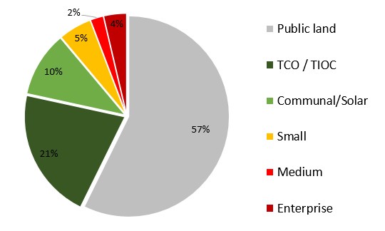
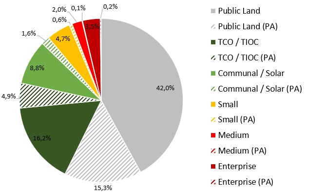
Figure 1 shows that by 2016, about 57% of Bolivia’s rural land was still public lands, while 31% had been granted communal property rights, either in the form of indigenous territories (TCO/TIOC) or communal land holdings. Only 11% was private property, divided between small properties (5%), medium-sized properties (2%) and enterprises (4%) (INRA, 2016).
Figure 1: distribution of rural property rights in Bolivia, 2016 (total area: 108 million hectares).
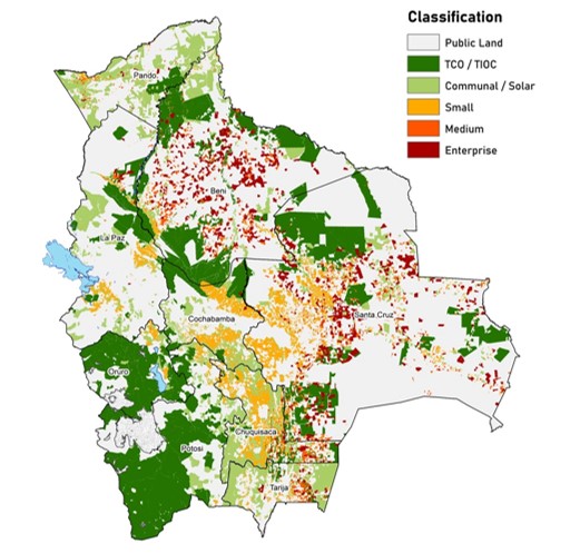
Map 1 shows how the different types of landholdings are distributed across the country. Enterprise properties are very much concentrated in Beni and Santa Cruz, while Pando is dominated by communal properties. Indigenous territories dominate in Oruro and Potosí, while small farms are most common in Cochabamba and Chuquisaca.
Map 1: distribution of rural property rights in Bolivia, 2016.
However, Bolivia also has almost 25 million hectares of Protected Areas (PA), and these are not just located on public land. Indeed, all types of properties have some overlap with protected areas. Figure 2 shows that 15% of Bolivia’s total rural land area is PA on public lands, while 5% is PA within indigenous territories, and 2% is PA on communal lands. About 1 million hectares within private properties have also been declared PA.
Figure 2: distribution of rural property rights and Protected Areas in Bolivia, 2016 (total area: 106 million hectares).
This means that we now have 12 different types of land to analyze. Table 1 shows the amount of land in 2016 in each of these 12 categories, as well as the amount and the share of this land that was deforested between 2016 and 2021 (according to the Hansen et al. (2013).
Table 1: deforestation rate by property rights category
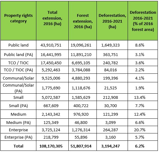
Table 1 shows that during the 6-year period from 2016 to 2021, Bolivia lost 6.2% of its forest, or about 3.2 million hectares. Most of the loss was on un-protected public lands (1,649,323 ha), followed by public lands with Protected Areas status (363,751 ha).
The rate of deforestation was highest on private properties owned by enterprises (20.7% over the six years), as was expected since this land can be confiscated if not in productive use. It was also high on medium sized properties (12.4%), which suffer from the same kind of uncertain property rights. Small private properties also saw a high deforestation rate (13.4%), despite their more secure property rights. But that may be because the land is really necessary for the family’s subsistence, as the average size of small rural properties is only 4.6 hectares.
The types of properties with the lowest deforestation rates are communally owned land and indigenous territories with protected area status. It is interesting to observe that deforestation rates are lower in protected areas with people and secure property rights (1.9% on communal land with PA and 2.2% on TIOCs with PA) than in PAs on public lands (3.1%).
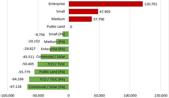
Given these differences in deforestation rates between different property rights regimes, we can carry out a very simple simulation to see how much more or less deforestation we would have had over the 6-year period, if 1 million hectares of public, unprotected land had enjoyed various alternative property rights. Figure 3 shows the results. If 1 million hectares of public land had been given to agricultural enterprises, we would have seen about 171 thousand hectares more deforestation on these 1 million hectares. In contrast, if the 1 million hectares had been declared public protected areas, we would have seen 56 thousand hectares less deforestation on that area. The option with the least deforestation, would be to give groups of people (indigenous or otherwise) communal ownership and a mandate to protect the area. In that case, we would have seen approximately 65 thousand hectares less deforestation.
Figure 3. Simulation: increase or decrease in deforestation over 6 years if 1 million hectares of public unprotected land were changed into different types of property rights
Conclusions and Recommendations
The results presented in this blog suggest that it is important to complete the process of land-titling in Bolivia as quickly as possible, so that people do not continue to use deforestation on public lands as a way of obtaining land titles.
Since the lowest deforestation rates were observed on communally owned land with protected area status, it might be a good idea to give groups of people collective land titles on the condition that they protect and sustainably manage the forest, rather than clear the land. This could work in areas where the value of forest products and services is particularly high, such as areas with a high density of Brazil nut trees, açaí palms, or wild cocoa or in areas with particularly high tourism potential.
However, in most areas, forest-based activities cannot compete economically with agriculture, unless additional benefits of the forest are taken into account. Espinoza et al. (2023) compare the value of agriculture with the value of forests in different parts of the Bolivian Chiquitanía region (the area with most deforestation) and find that some regions, especially in the northern part of the Santa Cruz department, are very valuable in terms of environmental functions (water regulation, carbon storage, erosion control, pollination, etc.), while others cannot compete with agriculture. They recommend that the areas that are simultaneously highly valuable in terms of provision of environmental functions and have low opportunity costs in terms of agricultural potential should be prioritized for protection. In contrast, areas with high opportunity costs could be prioritized for agricultural investment, but based on sustainable production models.
Getting deforestation under control soon is particularly important given the law passed last week by the European Parliament to fight global deforestation, which forces EU buyers to make sure the products bought have not caused deforestation. As part of this initiative, countries will be classified as low-, standard- or high-risk, and the latter will be subject to much stricter procedures and checks, which will make trade with the European Union much more difficult.
To make sure that the areas with high conservation value are protected, local communities should be put in charge of protection and sustainable forest management. However, they will need significant outside support and investment in order to build up sustainable economic activities, such as tourism and forest products with high value added. The funds necessary for this could come from a bilateral agreement of compensation for reduced deforestation in current and future protected areas, as explained in last week’s blog post.
References
Bolivia (2023). Nivel de Referencia de Emisiones Forestales por la Deforestación del Estado Plurinacional de Bolivia. Versión 1.0. 23 de enero. https://redd.unfccc.int/files/bo_nref_v1_20230123_final.pdf
Espinoza, S., Malky, A., Mendizabal, C., Vilela, T. Omiste, J. P. & Pinto, M. (2023). “Estudio de los beneficios económicos proporcionados por las funciones ambientales en el Bosque Seco Chiquitano. Reporte Técnico: Análisis Costo beneficio y Costos de Oportunidad.” Fundación Amigos de la Naturaleza (FAN) & Conservation Strategy Fund (CSF Bolivia). Santa Cruz. Documento en proceso de revisión final.
Hansen, M. C., P. V. Potapov, R. Moore, M. Hancher, S. A. Turubanova, A. Tyukavina, D. Thau, S. V. Stehman, S. J. Goetz, T. R. Loveland, A. Kommareddy, A. Egorov, L. Chini, C. O. Justice, and J. R. G. Townshend (2013). “High-Resolution Global Maps of 21st-Century Forest Cover Change.” Science 342 (15 November): 850–53. Data available from: https://earthenginepartners.appspot.com/science-2013-global-forest
INRA (2016). “Parcelas y predios titulados por el instituto Nacional de Reforma Agraria.” Data available from: https://geo.gob.bo/geonetwork/srv/spa/catalog.search#/metadata/f5c31a96-c4f0-4140-ba47-2cfbd931075a
SERNAP (2015a). “Mapa de áreas protegidas nacionales de Bolivia” Data available from: http://geo.gob.bo/download/?w=sernap&l=areas_protegidas_nacionales042015
SERNAP (2015b). “Mapa de áreas protegidas departamentales de Bolivia” Data available from: http://geo.gob.bo/download/?w=sernap&l=areas_protegidas_departamentales42015
SERNAP (2015c). “Mapa de áreas protegidas municipales de Bolivia” Data available from: http://geo.gob.bo/download/?w=sernap&l=areas_protegidas_municipales042015
- Log in to post comments